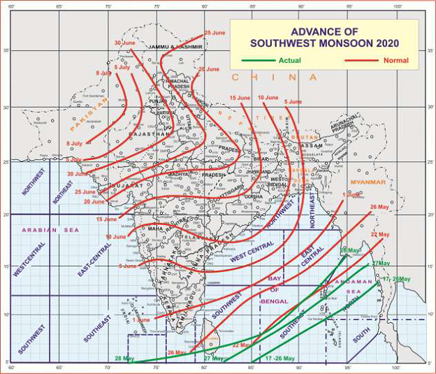
Delhi: May 28: According to the National Weather Forecasting Centre of the India Meteorological Department, with the strengthening of westerlies and increase in convective clouds, the southwest Monsoon has further advanced into some parts of Maldives-Comorin area, some more parts of south Bay of Bengal, remaining parts of Andaman Sea and Andaman & Nicobar Islands.
Conditions are becoming favourable for further advance of Southwest Monsoon into some more parts of Maldives-Comorin area during next 48 hours.
A Low Pressure Area is likely to form over southeast & adjoining eastcentral Arabian Sea during 31st May to 4th June, 2020. In view of this, conditions are very likely to become favourable from 1st June 2020 for onset of southwest Monsoon over Kerala.
A low pressure area has formed over westcentral Arabian Sea. It is very likely to concentrate into a Depression over the same region during next 48 hours. It is very likely to move northwestwards towards south Oman & east Yemen coast during next 3 days.
Under the influence of a Western Disturbance and an east-west trough in lower tropospheric levels, rain/thunderstorm accompanied with lightning, hail & squall at isolated places very likely over Western Himalaya Region & adjoining plains during 28th-30th May,.2020.
As a result, maximum temperatures over plains of north India and central & west India very likely to fall by 3-4°C during next 3-4 days. Hence the prevailing heat wave conditions are very likely to occur at isolated pockets of northwest & central India on today and abate thereafter.
Heavy to very heavy rainfall at isolated places over Tripura and Mizoram during next 24hours and Heavy rainfall over Assam & Meghalaya. Heavy rainfall at isolated places over parts of south peninsular India during 28th-31st May, 2020 with isolated Heavy to Very Heavy Rainfall over Kerala and Lakshadweep during 30th-31st May 2020.
Report: PIB


